The mapmaker’s first decision.
Today the mapmaker is seldom a 100 % cartographer, but often a journalist, an urban planner, soil scientist or something else with some knowledge of mapmaking. This change is primarily the result of the development of mapmaking technology, where producing a good map has become much easier and more accessible for non-specialists. The mapmaking is consequently often part of some general problem-solving process. The mapmaker’s first decision is to determine whether the creation and use of maps will aid in this process.
The main arguments for producing and using maps boils down to
- Everything happens somewhere, and a map is a good way of showing where.
- Maps are often the only way to visualise spatial patterns in statistical tables, e.g. are neighbouring municipalities similar or dissimilar with respect to some specific property.
- Maps are often the best way to investigate unknown relations, simply because functionally related events often occur in related (nearby) locations.
- Like other graphical visualisations, Maps use a semi-universal language understandable by a large audience.
- Maps are often engaging because the map-reader often can start by checking the information on locations that they have some form of relation to, i.e. where they live, where they have been on holiday etc.
There are, however, also arguments for not using a map:
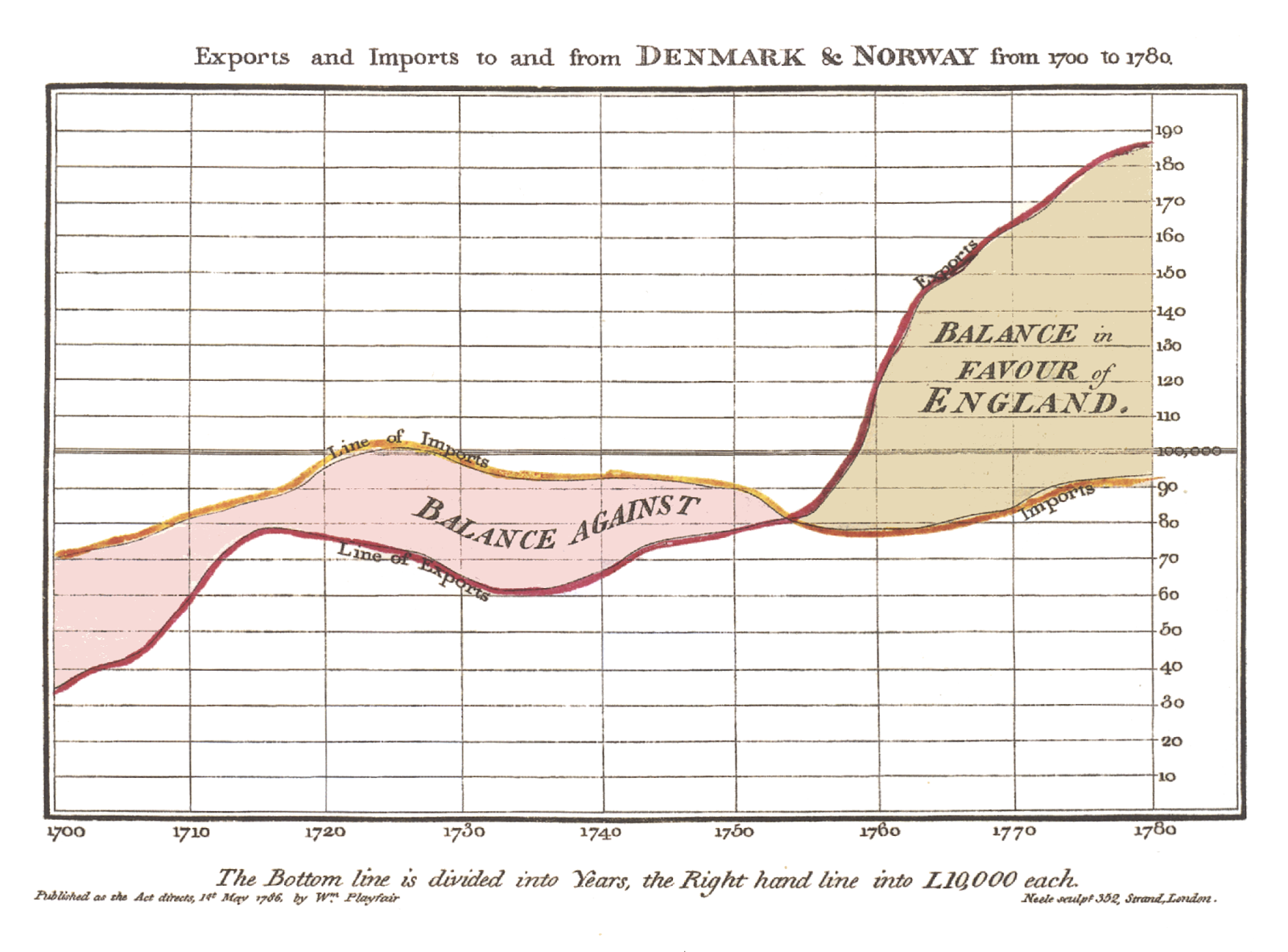
- Maps use the most vital aspect of visualisations, namely the x,y location, to represent space (location). If the location is not the primary aspect of what you want to communicate, then a map may not be the right choice. A classic example of this is William Playfair’s chart of trade balance between England and Denmark-Norway from 1786. Although there is a spatial dimension to this, the critical aspect is time and not space (location); thus, a map would not be appropriate.
- The location is secret: military installations or the site of endangered plants are typical case of this and often need to be obscured from maps. It can also be necessary to hide information that might compromise the privacy of your informants; for instance, it might not be a good idea to map the home address of all informants with some mental disease.
- The spatial pattern is straightforward. For instance, the map below depicts the result of a poll among American sports interested asking, “How surprised are you that Chicago has been eliminated from the potential host cities for the 2016 Olympics?”
- Your map-making skills/available resources are insufficient to depict the issue in question in a manner that makes sense for the intended. In other words, can you produce a map of the issue in question that the intended audience can read and is there time and money enough for this?
- The lack of a suitable communication channel whereby the map can be presented to the intended audience? e.g. website, newspaper, poster, etc.

If you still think you need to make a map after reading this, please go on to the posts on